Industrial sites and territories – Europe
The industrial revolution began in the period from 1760 to about 1830 in Great Britain, before spreading to continental Europe and further. The development of the industry attracted high numbers of workers into the cities, accelerated their growth, required the construction of infrastructures and subsequently restructured large territories. It also led to an acceleration of the environmental pollution through human activities and some scientist, like Paul J. Crutzen, see it as the beginning of the Anthropocene epoch.
The transformation of the Ruhr area
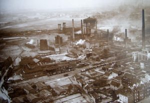
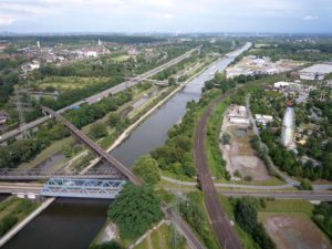
In Germany the coal and steel industry developed rapidly in the Ruhr area. At the end of the 19th and the beginning of the 20th century the Ruhr became the most important coal and steel area in Europe. Between 1905 and 1955 the population increased from 2,9 to 6,2 million. But the growth of the cities took place without defined rules. New housing areas were attached randomly to the existing settlements and large industrial sites were built in-between the urban areas without constraints, colonizing the whole space.
For several decades, the Ruhr was the industrial heart of Germany. But this monofunctional development without a long term vision, had a catastrophic impact when the decline of the coal and steel industry in Europe started. Through the second world war and the reconstruction the coal and steel crisis was delayed and began about 1955. In the 1960s the Ruhr area presented itself as a fragmented territory of 4435 km² marked by a declining economy, high levels of unemployment and a heavily polluted environment. An obsolete territory, while the new jobs of the service sector developed in the preserved green landscapes of southern Germany, where they still are today.
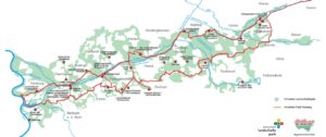
Facing this disaster the public authorities developed in the 1980s a unique transformation program that took place from 1990 until 2000, called IBA Emscher Park. The territory of the IBA Emscher Park focused on a conurbation of 800 km² along the river Emscher. The objective was to transform the territory by high quality projects that are integrated in a large scale guide plan and a new green landscape. The main approaches were to take the past as a leverage by assuming one’s industrial heritage, to change the image of the territory by art and culture and a strong engagement towards a sustainable development.
In 2009, during the discussions on the future shape of the Grand Paris, our office Rethink assisted the planning office of the region Ile-de-France (IAU) in conducting a French-German workshop on the IBA Emscher Park. We set up site visits and initiated discussions between French and German representatives on urban planning policies. During the workshop two initiatives stand out as exemplary for the transformation of former industrial territories: the industrial culture and the landscape park
Industrial culture
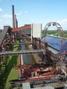
The rediscovery of its past is seen as an important element of the structural change of the Ruhr. The confrontation with its industrial past led to a reflection on its built witnesses. The decision to preserve the most interesting brownfields with their unique constructions was first rejected by the population. But on the long term their valorisation with interesting economic and cultural programs enabled to create a link between the generations and an identity for the territory. It was a sign against the common tabula rasa approach and the rehabilitated buildings and structures represent today important recognisable anchor projects.
Landscape park
The Emscher landscape park illustrates a change in the approach to urban nature. The Ruhr area presented itself as a fragmented urban landscape, crossed and cut by infrastructure and many sites were contaminated. The objective of the large scale landscape park was to unite this fragmented territory and to change the minds by turning the view from a grey past towards a green future. It was important to link isolated sites and landscapes, to create a new network of pedestrians and cycles path and to implement projects with a sense of great ecological efficiency and authenticity.
The IBA Emscher Park generally succeeded to attenuate the impact of the European coal and steel crisis, but not yet to reverse the decline of the Ruhr area. The transformation of these large industrial territories is a long-term process that takes several decades.
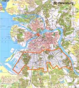
The industrial belt of Saint Petersburg
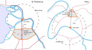
Differently than in the Ruhr area, where the industries developed in-between the settlements, the industries established often at the borders of the urban areas and created industrial belts around the city centre. In the 20th century the expanding cities leapfrogged these industrial belts to develop new suburbs. Later, due to globalisation and their new ‘inner city’ location these areas became less attractive for industrial uses. Located close to the city centre they represent today a valuable land reserve for a sustainable urban development.
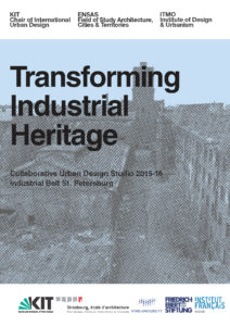
To further develop the research on the transformation of industrial areas the National school of Architecture of Strasburg (where the author is teaching), the University of Karlsruhe and the ITMO University of Saint Petersburg set up in 2015 a trinational urban design studio on the southern industrial belt of St. Petersburg. Nearly 60 master students worked on the sustainable transformation of this industrial area.[1]
The industrial belt surrounds the historic centre of St. Petersburg with railroad tracks, massive redbrick buildings, chimneys and water towers. It was mostly built between 1850 and 1910, while St. Petersburg was amongst the leading industrial cities in Europe. As the city grew, the industrial belt was gradually encircled by new mass housing districts and became a central periphery. Today the area is characterized by diversity and fragmentation. Some parts are still in industrial use, other parts are occupied by transitional uses or vacant and in a stage of decay. Situated at a distance of 4 km from the city centre the southern industrial belt offers a large potential to initiate a sustainable urban regeneration process.
The focus of the urban design studio was on the regeneration strategy and the spatial concept at different scales. Based on the analysis of the site and the local context, scenarios for the future of the southern industrial belt were developed. The students identified underused or inadequately used sites with a potential of transformation. They proposed urban projects for these sites and designed attractive, functionally and social balanced neighbourhoods in the framework of their scenarios. They focused on the adaptability of spaces and buildings and their accessibility by mobility networks. To reduce the consumption of natural resources energy efficiency, closed circuits and the necessity to reduce, reuse and recycle were central subjects.
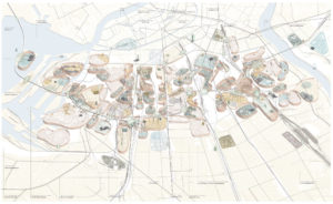
The work of the students highlighted that both, an overall strategy and spatial concept, are essential to set up a solid base for a long term regeneration process. Individual projects must then be evaluated in their quality and ability to support this strategy and concept before their construction. Without this evaluation process, short-term projects might later prove obstructive and, for example, hinder the continuity of a mobility network or the implantation of an important anchor project.
Many subjects, particular to the transformation of industrial areas, like land property or soil pollution, could not be taken into account due to the scale of the site and missing information. The local authorities supported and followed closely our urban design studio. It gave them the opportunity to integrate some aspects in the specifications of an international competition on the transformation of southern industrial belt conducted in 2016 by the Committee for Urban Planning and Architecture of St. Petersburg.
Saint Petersburg and Saint-Denis
Based in Paris our office Rethink developed a comparison of the southern industrial belt of St. Petersburg and the former industrial area of the Plaine Saint-Denis in the north of Paris. Both sites have a similar position in their metropolitan context, but a difference of 30 years in the start of their regeneration process. The objective was to illustrate the lessons to learn from the Plaine Saint-Denis.
Between 1840 and 1960 the Plaine Saint-Denis had gradually become a large industrial zone, providing 50000 jobs in 1940 on an area covering 750 ha (or 7,5 km²). In the 1970s, at the same time as the Ruhr area, the zone started to suffer from the deindustrialisation. One after the other manufacturing companies closed or relocated elsewhere. In 1986 there were about 200 ha of vacant land and the number of jobs had fallen to 27000. To face the challenge of its regeneration the public authorities founded in 1985 a public-public partnership called ‘ Plaine Renaissance’.
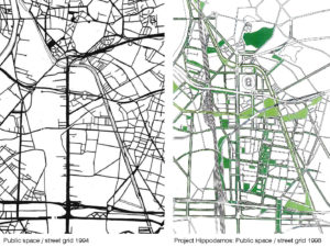
A particular aspect in the Plaine Saint-Denis regeneration process is the well organised beginning. Instead of transforming the site plot by plot, Plaine Renaissance first set up an inter-municipal development agreement and then initiated a planning and design competition for the whole area on this base. Secondly, instead of designating one single winner of this competition, they asked the competitors to team up and create one single design association, called Hippodamos 93. This association advised the local authorities during the following ten years on the regeneration process.
One of their first designs was a masterplan for a grid of generous public spaces for the area. They proposed to restructure the initial industrial plots and reconnected the Plaine to the neighbouring municipalities, including Paris. Wide multi-functional avenues were designed, running East-West and North-South. This new ‘green’ public space system, set up the framework for the following developments, while staying flexible in the details. Along the main axes of this grid new mixed-use buildings and environments were developed in time.
Generally the strength of Plaine Saint-Denis regeneration approach is that it is not based on a single flagship project, but on a coherent global strategy and spatial vision. Together with important interventions of the public authorities, a flexible spatial planning, the support of private investments and the use of opportunities, this approach has worked fairly well in the Plaine Saint-Denis regeneration process. During the process the public authorities managed the balancing act of integrating flagship projects like the 1998 World cup stadium while maintaining community involvement by local residents and businesses.
Paris Seine Amont
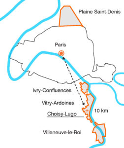
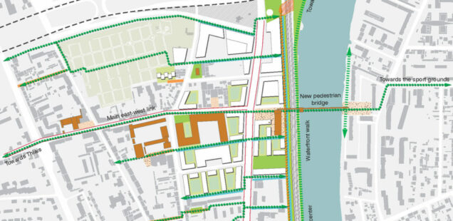
While the Plaine Saint-Denis is halfway through its regeneration process many other former industrial areas in the Paris Metropolis are still at its beginning. On important sector is composed by a succession of industrial areas along the River Seine south of Paris. They are situated on four municipalities: Ivry-Confluences, Vitry-Ardoines, Choisy-Lugo and Villeneuve-le-Roi
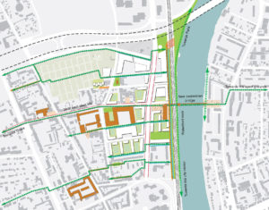
In 2010 our office had been commissioned with a feasibility study on the transformation of the industrial area ‘Lugo’ in Choisy-le-Roi. A site of 12 ha characterized by a heterogeneous urban fabric, composed by infrastructure, local activities, warehouses, commercial premises and former factories used by artists and housing. Similar to the Plaine Saint-Denis plan, but on a smaller scale, we first developed a grid of public spaces to connect the sector with its environment, especially the missing east-west links. Existing buildings were evaluated under different criteria for their preservation, rehabilitation or demolition. The objective was to preserve and develop as much jobs as possible and to introduce diverse housing and services to create a dense mixed-use urban neighbourhood. A former factory building with a heritage value should be preserved and valorised as a local cultural centre.
Generally the decline of industrial areas is an uneven and unplanned process. Some companies simply relocate or close down. Other downsize their production and sublet parts of their premises to other companies, while trying to restructure. To get a detailed overview on the situation of the local companies had been an important step for us to preserve existing jobs and to win the support of the local business community. Following we developed a guide plan in stages on the base of the public space grid. Each building project was divided into a negotiation, conception and construction or rehabilitation stage. The objective was to coordinate the requirements of the local actors, so that each company will find the space they need in new modernised premises. While liberating space to built new housing and education facilities.
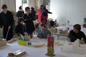
To include the inhabitants of this area in the regeneration process and to give them the opportunity to get information, express their opinions and participate, we recently set up an onsite model workshop. On a large model of 4 by 5 m in a scale of 1:100, the inhabitants built during a weekend a collective model of their future neighbourhood. It was not about building a clean architectural model, but using the model as a tool to exchange about the regeneration process of this former industrial site.
Author: Christian Horn is the head of the architecture and urban planning office Rethink in Paris, France
The article has been published in the magazine Project Baikal n°55
Sources
Brownfield revitalisation
Revit-nweurope.org. (2018). REVIT – brownfield revitalisation. [online] Available at: http://revit-nweurope.org/index.html [Accessed 2 Jan. 2018].
IBA Emscher Park
Reicher, C. (2008). Exposition Internationale d’Architecture et d’Urbanisme Emscher Park. Essen: Klartext-Verl.
Saint Petersburg
Transforming Industrial Heritage. Industrial Belt St. Petersburg. (2016). Collaborative Urban Design Studio. [online] Strasbourg: ENSA Strasbourg. Available at: http://www.strasbourg.archi.fr/publications/transforming-industrial-heritage-industrial-belt-st-petersburg [Accessed 5 Jan. 2018].
Engel, B., Horn, C. and Ziegler, V. (2016). Transforming industrial heritage in St. Petersburg. Project Baikal, Urban quarters(46), pp.138-145.
Plaine Saint-Denis
Lecroart, P. (2009). The urban regeneration of Plaine Saint- Denis, Paris region, 1985–2020. In: UN-HABITAT, ed., Planning Sustainable Cities: Global Report on Human Settlements 2009. UN-Habitat.


