The blue heart of Tatarstan – Russia
Riverscapes and settlements
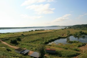
Water has always been and continues to be essential for human settlements. Alongside drinking water, water provided communities with fertile soil, energy to power hammers and mills. However, the most important function of the rivers and the sea over the centuries has been as a transportation route for trade and shipping.
Settlements developed on well situated places along the waterfronts. The waterfronts, natural borders of the territory, then frequently evolved to become lines of connection for countries, peoples and cities. This in turn caused them to be seen as symbols of identity, forging close emotional ties. Seafronts and rivers are important landmarks of territories and major sources of identity, history and imagination. They are also links, transport corridors and places of strong economic growth. But they can also represent a threat through flooding, today often due to uncontrolled urbanization, sealing of the natural soil, canalisation of rivers and climate change.
Cities worldwide are rediscovering their waterfronts. Deindustrialization, environmental awareness and improved urban infrastructures lead to a better water quality. Cities take advantage of their waterfront position to differentiate. They are becoming aware of the role of the sea and the rivers as a unifying thread, and are using it in their efforts to attract residents, jobs and investments in international competition between cities and the necessity to offer a higher quality of life.
The spatial development of the Republic of Tatarstan
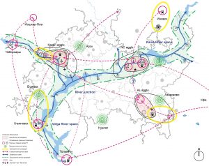
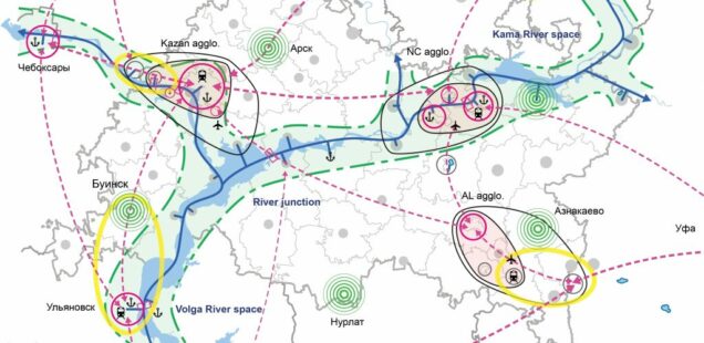
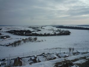
The Republic of Tatarstan is part of the Russian Federation and located in the Volga Federal District. It is crossed by two large and mythic rivers – the Volga and the Kama – and is generally divided by a dense network of river valleys. Three main agglomerations compose the spatial structure of the Republic of Tatarstan: the Kazan, the Kama and the Almetyevsk agglomeration. They are situated along the main transports lines and possess the central functions, in economy, education, health care, culture…
In 2014 our office rethink worked together with the Russian transport planning office Labgrad, Saint Petersburg, on the strategy of socio-economic development of the Republic of Tatarstan for the period up to 2030. In our study we set a focus on the potential of the Volga and the Kama River space to become a structuring river corridor, offering a high quality of life and spaces for the new economy. These river spaces create links on national, regional and local level. They form the blue heart of Tatarstan with their important natural spaces and developing urban areas ready to accommodate the economy clusters of tomorrow (biotechnologies, information technologies…).
We proposed that complementary to the existing and future main transport links, the territory should be systematically developed in relationship with the river spaces:
– Cities should develop their riverfronts for new high quality urban areas,
– Urban infrastructure must be modernized to protect the water quality,
– Bridges, ferry crossing and ice roads should be constructed on strategic points,
– Natural zones along the rivers must be protected and provide recreation space,
– Waterways, walking and bicycle paths should be developed for recreation and leisure.
Outside the cities, in the rural parts of Tatarstan, agriculture and forestry should be maintained and valorised. Timber construction should be developed to create a sustainable timber economy. Some rural cities are to be developed as a central point for their territory, providing local services for education, health, culture, economy, tourism…
The Kama agglomeration
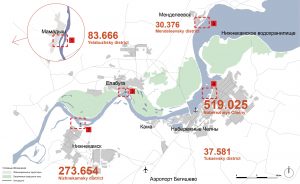
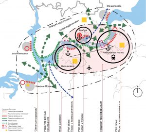
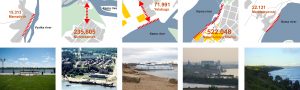
To show the potential of a riverspace for the territorial development we looked closer on the Kama agglomeration. The Kama agglomeration includes the three main cities of Naberezhnye Chelny, Nizhnekamsk, Yelabuga and smaller cities as Mendeleyevsk, Mamadych, Kamskiye Polyany. Cities of different sizes, populations and economic developments that form a poly-centric structure.
A main characteristic of this territory is the strong presence of water through the different rivers (Kama, Viatka, Toyma), the Nizhnekamsk reservoir and the ecological important wetlands. This presence of water should be in the centre of a coordinated development towards a connected and identifiable territory. The improvement of the links between the cities, the industrial zones and the natural spaces needs new innovative approaches:
– Turning the cities towards the riverfronts with high quality public spaces, new sustainable neighborhoods and protected natural environments,
– Secure a compact development of the cities in order to preserve the natural zones from urban sprawl,
– Strengthen and highlight the individual characteristic of each city: history, industry, university, tourism…
– Surveillance of the impact of climate change on fauna, flora and natural hazards,
– Creation of a metropolitan council with local administrations, private companies and civil society to set up a common development plan and coordinate its implementation
Each city could develop its riverfronts with its own individual characteristics. The open areas and natural spaces between the cities have to be maintained and valued. Bus, boat, train and bicycle networks should be developed between the points of interest and mobility. A common marketing and communications strategy for the agglomeration has to be created, addressing visitors, investors and qualified professionals:
– Situated on the Viatka River, Mamadych recently designed a public park along the riverfront. This initiative to connect the city and the water should be continued to strengthen its image as a place for recreation and holidays.
– Nizhnekamsk is situated in a distance of 1 km of the Kama River. The nearby city of Krasnyy Klyuch is situated on the riverfront. Nizhnekamsk has a road and tramway connection with Krasnyy Klyuch, that can develop as an accessible recreation place for the Nizhnekamsk population.
– Yelabuga is the main tourist destination of the Kama agglomeration. The city should redesign its riverfront with a modern river port for tourist boats, restaurants and parcs and a strong urban link towards its historic centre.
– Naberezhnye Chelny is the main city of the agglomeration and has the longest riverfront of all five cities. It could reinvent himself through an ambitious and varied development towards the river. A new neighbourhood along the waterfront with offices housing, shops and housing can be designed as the new meeting point of the city.
– The small industrial city Mendeleyevsk has a steeply sloping riverfront towards the Nizhnekamsk Reservoir. Viewing balconies and new dense housing operations could be built towards the riverfront.
The Nantes Saint Nazaire agglomeration
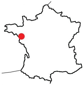
For comparison, we analysed the metropolitan region of Nantes and Saint Nazaire on the Loire river in France, that developed from a devitalize region in the 1970s into an attractive territory with a growing population though a coordinated development along its waterfronts.
The cities of Nantes and Saint-Nazaire form an important economic hub (harbour infrastructure, naval-, aeronautical construction) on the Atlantic cost of France with a population of 830 000 inhabitants. In 2003 they created the metropolitan administration of Nantes and Saint Nazaire to strengthen the cooperation of the two cities and to set up a common territorial development plan (SCOT). One main aspect of this plan is its focus on water, on the River Loire and the Atlantic Ocean, as an identity of this maritime territory. But also in terms of use of water, its environmental aspects and energy production.
This metropolitan region has some common points with the Kama region that justify the comparison. The region is composed of two major cities, Nantes and Saint-Nazaire, and several smaller ones. A main river, the Loire, crosses the region and represents its historic, cultural, economic backbone. Urban, industrial and natural areas alternate along its river shores. The agglomeration stretches over 75km along the Loire river, similar in size to the Kama agglomeration.
The main cities Nantes and Saint-Nazaire
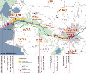
The city of Nantes is located on the Loire River, 50 km from the Atlantic coast. It is the 6th largest city in France. Until the 1970s Nantes had been an industrial city with a major harbour, before the harbour moved to the Loire River estuary at Saint-Nazaire. In the following 20 years economic difficulties forced many companies to close.
In 1985, Nantes was the first French city to develop a modern tram network and in 1989 it got connected to the national high speed railway network (TGV). Between 1990 and 1999, Nantes experienced a revival and a strong economic growth. The image of Nantes has changed by its new cultural vitality and a planning policy combining the renovation and revalorization of the built heritage and the creation of modern neighbourhoods. In 2013 Nantes held the title of European Green Capital for its efforts to reduce air pollution and CO² emissions, for its high quality public transport system and for its biodiversity.
Saint-Nazaire is situated on the Loire River estuary, close to the Atlantic Ocean. Its larger urban area includes 147 000 habitants. Saint-Nazaire has a long tradition of commercial fishing and shipbuilding. In the 1960s and 1970s the city suffered heavily from the downsizing of shipbuilding activity in Western Europe. For three decades Saint-Nazaire remained an economically depressed area with unemployment rates above 20%.
Today, the local economy is more diversified. The major industries are: shipbuilding (specialized in boats of more than 300 m length), aeronautical and mechanical engineering (Airbus group), harbour activities and services. Commercial fishing has almost completely disappeared. The municipality of Saint-Nazaire now turns the city towards the waterfront and the harbour, where students’ residences, a shopping centres and a new theatre will be built. The projects includes the integration of a large the submarine base from second world war, a business district near the train station and the construction of new ecological neighbourhoods.
Contemporary art as a driver of change: the «Estuaire» art festival
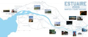
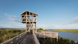
The «Estuaire» art festival is an example of the coordinated initiatives on metropolitan scale. Estuaire was a contemporary art festival along the estuary of the Loire River, from Nantes to Saint-Nazaire. Created in 2007, it presents art works of large dimensions, a specificity of this event. The works are situated in an urban or natural context. The festival took place in the summer of 2007, 2009 and 2012 and it attracted a large number of national and international visitors.
An objective of the festival was to bring the inhabitants and visitors out of the city centres into the large metropolitan territory of Nantes and Saint-Nazaire, focussing on active mobility (walking, biking). The contemporary art festival successfully changed the image of the territory and accompanies the transformation from an industrial towards a technology and cultural orientated territory.
Developing local tourism to structure the rural and urban territories
The protection of natural spaces and the development of the territory of Tatarstan towards its rivers space should be realized through local projects adapted to their context, but integrated in an overall strategy and approach. Similar as the Estuaire art festival. For example tourism is an important tool to structure the rural and urban territories. It should be as diversified as the landscapes and cities of Tatarstan, and develop an offer for different desires, needs and budgets. The Kama river space starts at Kazan and the confluence of the Kama and Volga rivers. This well connected city is a good starting point for the development of tourism along the riverspaces with the following guidelines:
– The main cities offer transport infrastructure and cultural highlights,
– Smaller pleasant cities in proximity could develop the business tourism as congress cities,
– Attractive points of interest along the road network invite travellers to take a break,
– Rural accommodations offer recreative holidays,
– Farms accommodate families with young children,
– Specific sites are prepared for active cultural holidays, like industrial heritage,
– Art festivals attract international art lovers…
All these offers participate in building and maintaining an active and living territory. To be successful they should be developed, constructed and marketed under an umbrella brand, combining the attractions by creating a network of locations and organizers from culture, leisure, tourism, business and industry.
Territories with diversified river spaces should develop with a regard to their waterfronts. A development in which the protection of the natural landscape is essential and cities needs to maintain a compact growth. The republic of Tatarstan should set a focus on their networks of rivers, develop an overall strategy and encourage and coordinate local initiatives to become a more attractive territory. A higher quality of urban life for the whole population and to countersteer the brain drain to the Moscow metropolitan region.
Project Team
Office RETHINK – architecture, urban planning; www.rethink.fr
In a team with: Labgrad, engineers
About the office Rethink
The office RETHINK , architecture and urban planning, works on the sustainable transformation of urban fabric and metropolitan areas, the quality of public spaces, and the renovation and restructuring of existing buildings. Based in Paris the office is particularly implicated in the development of the Paris agglomeration, also called “Grand Paris”.
> (English) Link to the territorial study ‘Tatarstan’ of the office Rethink
> (Français) Lien vers l’étude territoriale ‘Tatastan de l’agence Rethink
Author: Christian Horn is the head of the architecture and urban planning office RETHINK in Paris, France
The article has been published in the magazine Project Baikal n°50


