On the edge of the Paris metropolis – France
A guide plan for the development of the natural space ‘Joncs Marins’ on the edge of the Paris metropolis
Like most major cities worldwide the city of Paris has grown since its foundation in the 3rd century BC by a Celtic people called the Parisii, who gave the city its name. Its growth in population accelerated from the midst of the 19th century, when the city exceeded the number of 1 million inhabitants. In consequence of its population growth the city started to expand, urbanizing woodland and farmland. Large woodlands, once situated outside of the urban area and preserved by their use as hunting grounds, had been enclosed by the expanding city and form today its main parks. Like the Bois de Boulogne, a 845 hectares natural space in the western part of the city of Paris, or the Bois de Vincennes, covering 995 ha in the eastern part of the city.
Today Paris is a metropolitan area of over 12 million inhabitants, covering over 17 km². And the metropolitan area is still expanding, urbanizing in average 2400 ha/year, of which 1900 ha are fertile farmland. It is an ongoing development with a strong negative impact on the natural environments and the quality of the urban areas. An expansion by low density urban forms that cannot be connected by public transport and offer few services. But it is continuously sealing the natural ground and reducing the biodiversity of the metropolitan area.
The Joncs Marins
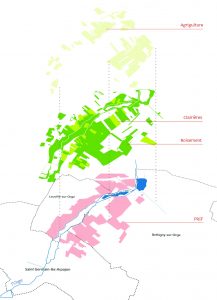
The site of the ‘Joncs Marins’ is a natural open space located about thirty kilometres south of Paris, just outside of the outer motorway belt of the Paris Metropolis. An important north-south railway line crosses the municipality of Brétigny-sur-Orge in the east of the site, connecting Paris with Orleans.
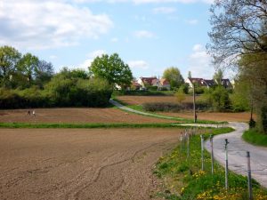
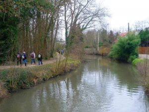
The site itself belongs to the valley of the river’ Orge’, that flows 15 km further to the north-east in the river Seine. It is a site with a high diversity of landscapes, with woodlands, meadows, wetlands, rivers, lakes and farmland… and situated on the edge of the metropolitan area. Further south the valley of the river Orge lead in the agriculture belt of the region. But the process of the expansion of the metropolitan area is pushing forward with different projects for housing, industrial and commercial areas. Nearby greenfields are sealed and constructed, as the area is well connected to the road network and the railway line gives direct access to the centre or Paris.
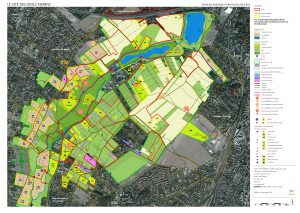
Recognizing the ecological and recreational value of this site and foreseeing the growing pressure of urbanisation, the Green Spaces Agency of the region Ile-de-France (AEV IdF) agreed in 1989 with the three concerned municipalities (Brétigny-sur-Orge, Saint-Germain-lès-Arpajon and Leuville-sur-Orge) on its protection. They established a special legal perimeter, called PRIF, extending over 175 ha and about 3 km long and 2 km wide. Inside the PRIF, a regional perimeter of real estate intervention, the region has a right of pre-emption in case a landowner wants to sell his ground. With this legal tool, the region aims to own the land inside the perimeter on the long-term and to preserve it from urbanisation, to develop its biodiversity and to make it accessible to the surrounding population as a recreation area.
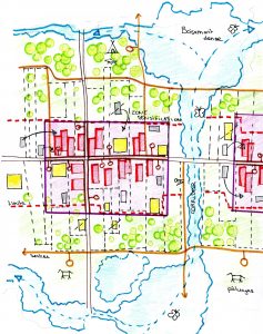
But the establishment of the PRIF did not had the expected effect. During the 25 years the AEV IdF did not managed to buy the whole land inside the perimeter, as the landowners found way to bypass the right of pre-emption. Parts of the woodlands were increasingly occupied by people in precarious situations, living in mobile homes, clearing the trees, constructing housing. And the municipalities continued to transform agriculture land into constructible plots on the borders of the site, allowing the construction of housing and reducing the area of the farmland and natural spaces. As a result, the incoherent development and uncoordinated urbanization lead to a growing fragmentation of the site. Buildings emerge alongside farmland next to meadows, woodlands and rivers.
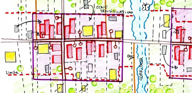
A comprehensive guide plan for the site
To improve the situation and the collaboration with the municipalities, the AEV IdF commissioned our office Rethink with a team of landscape architects, sociologists, ecologists and specialist in agriculture to work out a guide plan for the development and management of this natural open space. The aim of the guide plan was to preserve the site and to enhance its quality. To develop the relationship between the different functions and uses of the site and to make it accessible to the population in the surrounding residential area as place for recreation. With this guide plan the different interventions of the local actors should become part of a transversal and global sustainable development approach.
Our guide plan is based on five main work areas, that have them been detailed in several operational sector.
1. Structuring the site of the Joncs Marins
– To create a network of paths and to strengthen the structure of the landscape.
2. Discovering the site of the Joncs Marins
– To enhance the landscapes and to reveal the territory.
3. Cultivating the site of the Joncs Marins
– To maintain and diversify the viable and functional farmlands.
4. Protecting the site of the Joncs Marins
– To protect and maintain the woodlands and the biodiversity
5. Living on the site of the Joncs Marins
– To organize and manage the housing within the site and at its borders
Structuring the site of the Joncs Marins
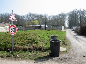
The success of the different interventions and planned projects requires above all the improvement of their accessibility. Portions of existing roads or paths are redesigned for more security and to encourage mixed use of pedestrians, cars, tractors, bicycles and horses. Measures such as limited speed zones (50km/h on main roads, 30km/h on secondary roads) are established, sidewalks and shared lanes are created.
The insertion of the roads/paths in their environment is reworked with special treatment depending on their typology (small twisting or larger straight path, secondary or main roads). The borders of the paths are especially treated and designed with shrubs, ditches or hedges. Meanwhile, a soft transport network is defined within the site, with the creation of 15 footpaths, equestrian and cycling paths. It facilitate the access from the urban areas to the green valley floor.
Discovering the site of the Joncs Marins
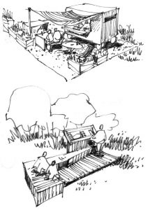
To broaden the possibilities to discover the site and its landscape, installations, constructions and special programs are proposed. Such as the creation of several thematic and educational path (on biodiversity, agriculture, by feed or on horseback). Additionally new observation towers and promontories give the opportunity for relaxation and contemplation of the landscape.
The creation of family gardens with 30 plots of 100m2 in Brétingy-sur-Orge is progressing and three new car and bike parks to accommodate the public are foreseen. The aim is to transform the Joncs Marins in a living site, by creating activities to bring a new dynamism to the territory. These are to be developed in partnership with local associations, schools or youth groups, in their management and in their construction.
Cultivating the site of the Joncs Marins
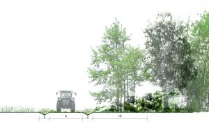
An important measure is to avoid the decline of the field crops, which would lead to scrub encroachment and loss of open spaces. Agriculture represents 54% of the open spaces inside the PRIF, of which are 22% cereals, 18% lie fallow and 11% are pasture. Actions to secure the land and curb land fragmentation are established in the guide plan. Maintaining the field crop also requires the access for agricultural equipment to the land. The opening of a path suitable for agricultural vehicles is proposed along the river Orge.
Complementary to the field crops, the reintroduction of market gardening diversifies the types of crops. To give it a boost, an operation of community-supported agriculture is recommended, particularly on the municipality of Leuville-sur-Orge. Six lots of 3 to 6 ha are provided for this purpose, three on Leuville-sur-Orge, two in St Germain-lès-Arpajon and one on Brétigny-sur-Orge.
Protecting the site of the Joncs Marins
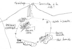
The woodlands of the PRIF can be are divided into two parts: moist forests on 13 ha and other woodlands on the hillsides covering 50 ha. The former, which have a high ecological interest, are located in the regional ecological corridor of the Orge valley and the objectif is their preservation. The woodlands on the hillsides are more fragile and threatened by urban sprawl and land clearing. The aim is to protect and enhance them. Precautions and strict requirements of managements are set up to organize the cuts, the renewal of the trees and the pruning.
Biodiversity can be enhanced by careful management of the meadows in functions of their environmental characteristics. Management methods such as eco-grazing by animals or scything are recommended for wet meadows or to reclaim wastelands.
Living on the site of the Joncs Marins
The growing number of people in precarious situation living in the woodlands is a social and ecological problem. Inside the PRIF, the sociologists interviewed 115 households (about 302 persons) to get more information about their situation. As today they live scattered over the woodlands, we developed an approach to propose to the interested families to move to certain areas on legally attributed plots. The aim is to built in collaboration with the families new neighbourhoods on the site in which public services, like urban and social infrastructure, can be provided. So to shift from illegally occupied plots to a legal land ownership and to recover the woodlands in order to restore their ecological qualities.
Besides we worked with the municipalities to stabilize today’s limits of the urbanized areas. Interesting urban forms with a higher density and a well-designed transition between built areas and natural spaces can slow down the extension of the surrounding urban areas on former farmland.
This guide plan, developed by the office Rethink and a team of specialists, allows the AEV IdF, the municipalities and other local actors to coordinate their interventions for the long-term preservation of the natural space of the Joncs Marins.
On a larger scale the site plays an important role in the preservation of the regional ecological corridor of the Orge Valley. On the local scale, situated in an increasingly urbanized territory it acts as a multifunctional natural space, a pole of biodiversity and a recreational space for urban dwellers. The preservation of these spaces become indispensable to maintain the presence of natural spaces with high ecological quality nature in the metropolitan areas.
Project Team
Office Rethink – architecture, urban planning; www.rethink.fr
In a team with: FORS, sociologists; MTA, landscape architects; OGE, ecologists; TRIOG, specialist in agriculture;
About the office
The office Rethink, architecture and urban planning, works on the sustainable transformation of urban fabric and metropolitan areas, the quality of public spaces, and the renovation and restructuring of existing buildings. Based in Paris the office is particularly implicated in the development of the Paris agglomeration, also called “Grand Paris”.
> (English) Link to the territoral study ‘Joncs Marins’ of the office Rethink
> (Français) Lien vers l’étude territorial ‘Joncs Marins’ de l’agence Rethink
Author: Christian Horn is the head of the architecture and urban planning office Rethink
The article has been published in the magazine Project Baikal n°49


